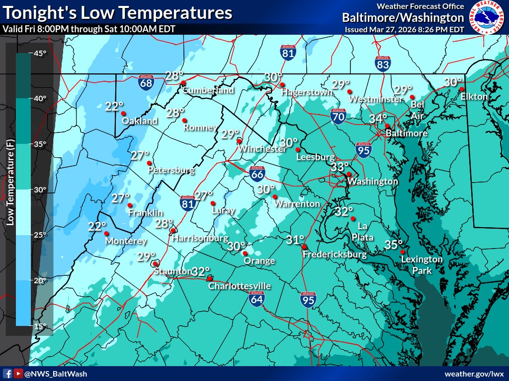
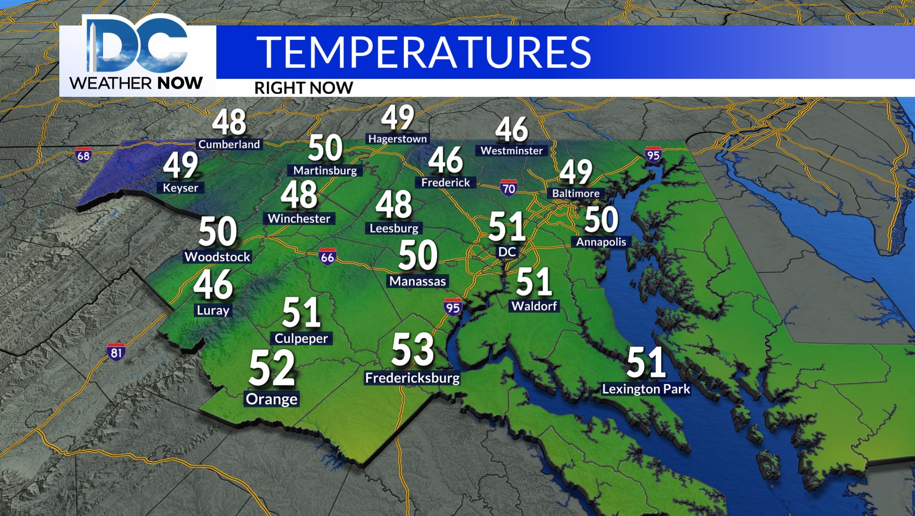
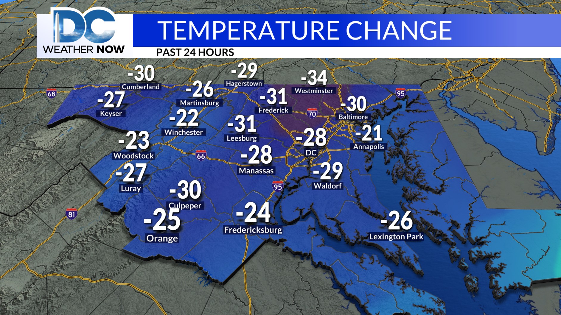
NWS Baltimore-Washington
NWS Baltimore-Washington @NWS_BaltWash ·
Increased northwesterly winds & lowering relative humidity values will lead to an elevated fire danger through this afternoon for areas along & east of I-81. Try to avoid burning today with dry conditions & warm temps through Tuesday. #MDwx #VAwx #WVwx #DCwx
4
2.4K
NWS Baltimore-Washington
NWS Baltimore-Washington @NWS_BaltWash ·
SATURDAY MARCH 28, 2026: Colder temperatures prevail through the weekend with freezing low temperatures across the region. Incoming high pressure will cause drier and sunnier conditions overall, before warm air returns early next week. #DCwx #MDwx #VAwx #WVwx
6
2.1K
Jackie Layer
Jackie Layer @WeatherJackie ·
Both weekend days feature ample amounts of sunshine, but Sunday is the pick of the weekend thanks to seasonable highs around 60. #DCwx #MDwx #VAwx
1
172
Jackie Layer
Jackie Layer @WeatherJackie ·
Starting off in the lower 30s Saturday AM before we bounce back to around 50 Saturday PM. These colder temperatures are more typical of mid to late February than late March for the DMV. #DCwx #MDwx #VAwx
1
175
Matt Miziorko
Matt Miziorko @SnarkyEM ·
Data is live! This second station in Harford County will increase surface observations along the Mason-Dixon Line. Great work by the crew to get this equipment installed and running in less than three hours! #MdWx Station page: mesonet.umd.edu/whiteford MADIS ID: 041MD
Joey Krastel Joey Krastel @NimbusStorms ·
The 2nd for Harford County is up! This is number 41 across the state. This one is in the Pylesville/Whiteford area of the county.
1
291
NWS Baltimore-Washington
NWS Baltimore-Washington @NWS_BaltWash ·
Temperatures will drop significantly tonight as a cold front exits the region. Lows will range from the 20s over the Alleghenies to the mid-30s towards the bay. Rain showers will start to dissipate tonight; skies should clear tomorrow. #MDwx #VAwx #WVwx #DCwx
1
7
3.8K
Ava Marie
Ava Marie @AvaWBAL ·
Getting reports of sleet mixed in with the rain around Baltimore and north. Let us know if you are seeing any ice pellets. @wbaltv11 @wbaltv11 #mdwx
2
1
1.2K
Jackie Layer
Jackie Layer @WeatherJackie ·
4:30pm Friday: For your Friday evening commute, scattered showers continue, especially south of I-66. Temperatures are hovering in the upper 40s to lower 50s.☔️ #DCwx #MDwx #VAwx
2
1
198
Jackie Layer
Jackie Layer @WeatherJackie ·
From 80° Thursday to around 50° this afternoon -- nearly a 30-degree drop from this time yesterday 😲 #DCwx #MDwx #VAwx4
1
204
Montgomery Co. MD OEMHS
Montgomery Co. MD OEMHS @ReadyMontgomery ·
An Extreme Cold Alert has been issued for Montgomery County on Saturday 3/28 from 3am until 11am. Expect the wind chill below 32 degrees F. Wear layers if you go outside. Take extra precautions if you spend time outdoors. More info: bit.ly/2JdmQ3C #MoCo #MDwx
1
870
Giovanni Rizzotti
Giovanni Rizzotti @Gio_wx ·
BREAKING: The fourth Maryland tornado of 2026 has been confirmed in Carroll County, near the community of Prospect Hills, from severe weather on the evening of March 11th. This tornado was rated EF-0 with 80mph winds. This is the second tornado in Carroll County in 2026. #MDwx 👇
iembot_dmg iembot_dmg @iembot_dmg ·
LWX issues Damage Survey PNS (Max: EF0) at Mar 27, 1:53 PM EDT ...NWS Damage Survey for 03/11/26 Prospect Hills MD Tornado... mesonet.agron.iastate.edu/p.php?pid=2026…
IEM :: PNS from NWS LWX

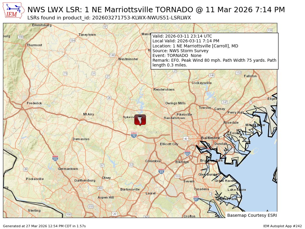
PNS issued by NWS LWX at 27 Mar 2026 17:53 UTC

From mesonet.agron.iastate.edu
5
828