LISA Institute - Seguridad, Intel y Geopolítica
LISA Institute - Seguridad, Intel y Geopolítica @LISA_Institute ·
La disciplina alrededor de las imágenes está ganando terreno en el campo del análisis y la #Inteligencia ➡️ Explicamos las principales fases de #IMINT, desde la identificación hasta el papel que ejerce el Analista y la influencia de la #IA 👇lisanews.org/inteligencia/l…l
Las principales fases en IMINT y el papel del Analista de Imágenes - LISA News

El alumno del Curso de Analista IMINT (Inteligencia de Imágenes) explica las fases de identificación y reconocimiento en IMINT.

From lisanews.org
1
41
IndianOsintGuy
IndianOsintGuy @dharam81659 ·
🛰️ OSINT: Smoke observed at Kuwait International Airport (Mar 25) 📍 29.2404°N, 47.9710°E Satellite imagery shows: • Smoke plume near airport infrastructure • Likely active/recent fire Observation ≠ attribution. #OSINT #GEOINT #IMINTb9
55
Jesús Manuel Pérez Triana 🌻
Jesús Manuel Pérez Triana 🌻 @jpereztriana ·
Replying to @jpereztriana
110) 🇮🇷🌐Guerra en el Golfo Pérsico. China mostrando los movimientos de las grandes unidades navales de EE.UU. #NewSpace #IMINT x.com/MonitorX99800/…
MonitorX MonitorX @MonitorX99800 ·
🇮🇷🇺🇸⚡️– Chinese satellite MizarVizion releases satellite images showing the locations of the USS Gerald R. Ford and USS Abraham Lincoln. The USS Gerald R. Ford has moved further south, but is staying out of the range of Houthi missiles, in the Central Red Sea off the coast of Jeddah. Meanwhile, The USS Abraham Lincoln has retreated to the coast of Salalah, and now has more than 1,100 km between Iran and the carrier, after one of its escorts was attacked by Iranian gunboats earlier this week. The USS Abraham Lincoln was at the beginning of the week, less than 350km off Iran's coast.
1
1
1K
Jesús Manuel Pérez Triana 🌻
Jesús Manuel Pérez Triana 🌻 @jpereztriana ·
Replying to @jpereztriana
97) 🇮🇷🌐 Guerra en el Golfo Pérsico. Restricciones en empresas de servicios comerciales de imagen por satélite. 🛰️🔍 #IMINT #NewSpace x.com/MarioNawfal/st…
Mario Nawfal Mario Nawfal @MarioNawfal ·
🚨🇺🇸🇮🇷 BREAKING: Satellite images of the Middle East are reportedly disappearing. Planet Labs, the world's largest commercial satellite fleet, just imposed a 2-week blackout on high-resolution imagery of the entire Middle East. Iran. Gulf states. Allied bases. All of it. Gone. Two weeks covers the entire war to date. This matters more than it sounds. For the past decade, commercial satellite imagery was how journalists, researchers, and citizens pierced the fog of war. It's how we knew Russian troops were massing before Ukraine. How we tracked damage at Aramco. How independent analysts counted craters at Dimona. That era just ended. Quietly. With a policy change on a usual day. When governments control the cameras, they control the story. You're no longer watching a war... you're watching their press release. The most transparent conflict in history, documented in real time, every strike geolocated, every crater counted, just went dark at the exact moment it started escalating. Ask yourself who benefits from the world not seeing what's happening right now over Iran. Then ask yourself why nobody's talking about the blackout. The fog of war just became a subscription service that got cancelled. The Economist
1
526
Inevitable Adrian Adastra 🕷Hat / Hats
Inevitable Adrian Adastra 🕷Hat / Hats @adrianadastra ·
Replying to @MedmenhamAssoc
@MedmenhamAssoc @Sandbagger_01 @rafwytonee @SpringWyton @BeaverWestminst Ignore #IMINT at your peril
Shanaka Anslem Perera ⚡ Shanaka Anslem Perera ⚡ @shanaka86 ·
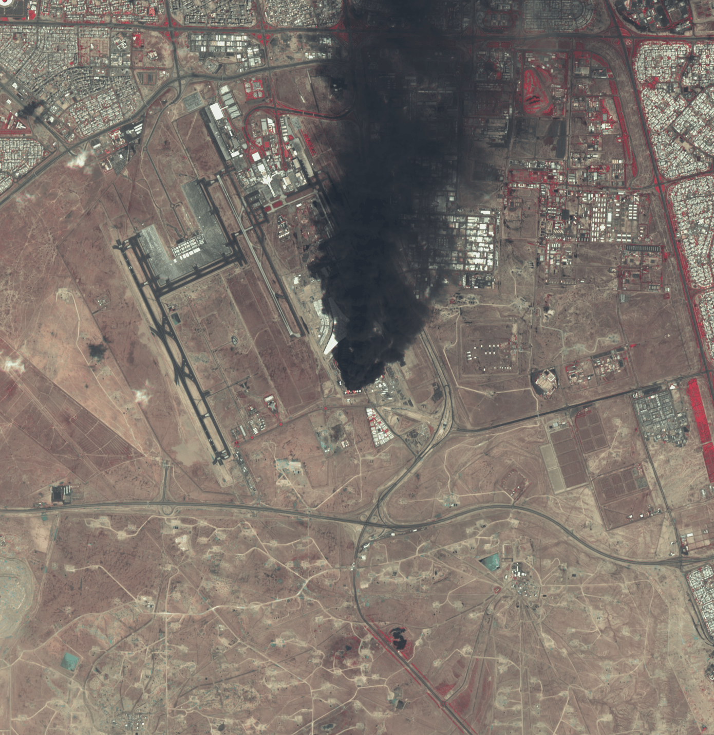
Look at this image carefully. You are looking at a Chinese commercial satellite photograph of Prince Sultan Air Base in Saudi Arabia. Every red box is an artificial intelligence model identifying a US military aircraft by type. Every label is in Mandarin. And the base you are looking at is the one Iran fired ballistic missiles at on Saturday night. A company called MizarVision, founded five years ago in Hangzhou, published this. Not the Pentagon. Not the CIA. Not a classified intelligence briefing delivered to the Situation Room. A Chinese startup with access to sub-meter resolution Earth observation satellites and an AI object detection model that can distinguish a KC-135 Stratotanker from a KC-46 Pegasus from orbit. Aviation Week confirmed what the image shows. Fifteen KC-135 aerial refueling tankers. Six KC-46 Pegasus tankers. Six E-3 Sentry airborne early warning aircraft, which is significant because only thirty one E-3s remain in the entire US Air Force inventory worldwide, meaning roughly a fifth of America’s operational AWACS fleet is parked on a single ramp in the Saudi desert. Two E-11A Battlefield Airborne Communications Nodes. C-130 Hercules transports. C-5 Galaxy heavy lifters. The backbone of Operation Epic Fury, catalogued from space and published on Weibo. This is the base that Iran targeted. AFP journalists in Riyadh reported explosions in the eastern part of the capital with thick smoke rising. The Saudi Foreign Ministry condemned Iranian attacks targeting Riyadh and the Eastern Province. Saudi air defenses intercepted the projectiles. But the image you are looking at was published days before the strike. Which means Iran had exactly the same intelligence picture that MizarVision gave the entire world for free. This is what the democratization of intelligence looks like. In 1991, only the United States could see individual aircraft on a ramp from space. In 2003, a handful of nations had that capability. In 2026, a Chinese startup publishes annotated satellite imagery of American force dispositions on social media, and Aviation Week runs the analysis before the first missile is fired. Defence Security Asia captured what this means: sub-meter resolution imagery distinguishing individual aircraft types fundamentally alters the secrecy calculus of pre-strike deployments. You cannot mass two hundred aircraft across half a dozen bases and keep it secret when commercial satellites photograph every ramp twice a day and AI models label every airframe before an analyst finishes their coffee. The age of hidden buildups is over. Every deployment is now observable, catalogued, and published in near real time by companies with no security clearance and no allegiance to anyone. The next war will not be planned in secret. It will be watched from orbit by everyone, in every language, simultaneously. open.substack.com/pub/shanakaans…
71